Talking Tactile Map on Trial in Japan(April 2003)
By Kazumasa Kobayasi (CHIRI Geographic Information Service Co., Ltd)
Mention the name "Talking Map", and what springs to mind? A product of the most advanced high technology (such as a car navigation system using a Global Positioning System?) Or a digital map operated by using a computer? Unfortunately, even with the development of these products, people with visual disabilities cannot use ordinary maps. But now a "talking tactile map" for individual users has been developed. It is printed on paper, which is combined with modern electronic technology - a simple interface - which can be easily operated by people with visual disabilities and the elderly. The developer is CHIRI Geographic Information Service Co., Ltd., a company specializing in producing maps.
Equipment
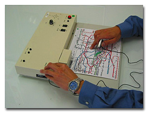
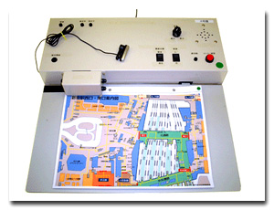
The equipment consists of two parts. One is the board (to support the map) and the other is a box-like operating part. The touch sensor on the board recognizes the coordinates on the map, and the voice guidance corresponding to the coordinates is recorded and played in the operating box. No connection to a computer is necessary. Simply turn it on and set it.
Unlike large equipment found at places like stations, it is small enough that the individual can use it at home before going out, or (in the case of students) at school to learn about maps or geography. In addition, it has a helpful memo function that records the user's own voice guidance. When the map is replaced, all the voice guidance is automatically changed in correspondence with the new information.
Map and Voice Guidance
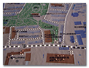
The talking tactile map superimposes Braille and tactile symbols on transparency onto ordinary printed maps. Using the company's knowledge of this area, its letters and colors are designed to be easily-to-recognize by the elderly and the visually impaired. Braille and tactile symbols are located to match the actual area in the background map. What look like lines of white circles on the photo are actually transparent tactile symbols and Braille, which represent roads or parks. Buildings, signals and other features are also presented, enabling users to identify their location, and to get an accurate sense of distance and direction. For example, large circles on roads signify a distance of 20 meters from one circle to another. Thus 5 circles equates to 100 meters.
If you lightly push the Braille or tactile symbols on the map with your finger, you can hear relevant pre - recorded voice guidance.
By pushing tactile symbols or Braille on roads, for example, the message will identify not only the name of the street, but locations of the signals with sound guidance, the name of the bus stop and the destination of the bus. In a railroad route map if you push a tactile symbol on a station, you will hear the name of the station, and what lines it is connected to. The map will also reveal the location of the station staff, and the toilets. It is possible to input a timetable too.
Recording of voice guidance
A recording function is available at any place on the map, by changing the switch to recording mode. As the individual presses the recording button, he or she pushes the tactile symbols at the location and talks. They then put convex stickers on the map to remember the location of the recording
Universal Design
The map has been produced in such as way as to be practical for both people with and without visual disabilities to use simultaneously. At present the equipment is too large to carry around, but convenient at home or at school. When going out, the user can get help from people, as long as he/she carries the paper tactile map.
It cannot inform the user of their current location, or offer directions like a car navigation system. However, even current GPS technology is not precise enough to guide visually disabled people with detailed information around town, and nothing is better than friendly help. We hope that this tactile map will be used to encourage the disabled people to get such help.
Further Development
At present further development is under way, and a lot of research is being carried out. The aim is to make the equipment smaller and more mobile, to improve its operational ability when recording voice guidance and to improve its applicability as a `fixed type` guidance map (which could be approached in town at a terminal) GPS could show the approximate location of relevant tactile maps in a specified area.
Thus development continues with the full application of available technology. The aim is to equip the map with an interface that is simple enough for people with visual disabilities to use intuitively and without difficulty. We hope to be able to announce more on this development soon, such is the pace of advancement.
The "Talking Tactile Map" is being developed under a project funded by Association for Technical Aids, Inc. 2002, to support research and development of assistive equipment.